Register for free and continue reading
Join our growing army of changemakers and get unlimited access to our premium content
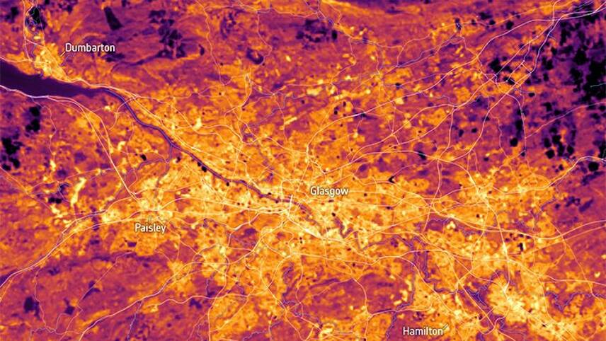
Satellite image of Glasgow land surface temperature. Image: ESA NCEO (U. Leicester)
Digital technologies can help reduce global carbon emissions by up to 15% – one-third of the 50% reduction required by 2030 – through solutions in energy, manufacturing, agriculture and land use, buildings, services, transportation, and traffic management. These transformative technologies, combined with the use of geospatial data provide vital insights for climate change management.
Geospatial data is information describing the physical location of geographic features, their relationship to other features and associated statistical information – data insights that can help governments and businesses to adopt policies and mitigate risk to protect the future of our planet.
The new Net-Zero Standard – a Science-Based Targets initiative (SBTi), launched just before COP26 – provides a government-mandated framework for businesses to work towards Net Zero targets. The Net-Zero standard is the first of its kind in the world and should significantly change the business landscape. To have a hope of hitting the NetZero target we need to collaborate, share data, monitor, adapt: to act and to act now.
Going forward there will be an even greater need for the evidence and insights that location data can provide – you can only manage what you can measure. Governments and businesses need accurate, detailed information that people can trust, and this is what geospatial data offers – precise, reliable data that can be used to track climate change and monitor the impact of measures used to combat it. OS’s vision is for us all to ‘see a better place’. They are world leaders in geospatial services and create location insights for positive impact for both people and the planet.
Helping enable renewable energy investment
It is essential to efficiently identify locations where renewable energy plants can be built and where renewable energy sources can be found. OS has identified three areas in which geospatial can help.
1) Mapping for coastal erosion
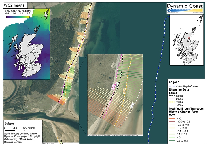
We must consider natural changes that are already happening. Climate change is causing rising sea levels and there is the potential for populations to be exposed to coastal erosion. Our coastlines are constantly evolving. A past approach to coastal management is to build seawalls. With ever-increasing costs and resources required, and with more infrastructure being offshore such as windfarms, including floating windfarms, we need to know how to position the onshore supporting structure and that needs an understanding of coastal and sea-level change.
OS has the expertise and mapping capabilities to help with monitoring coastal erosion and adapting to change. In Scotland, The Dynamic Coast project used OS data alongside additional surveys to develop new maps that serve as a coastal change planning tool to build resilience and adapt to the pressures of climate change and sea level rise. Detailed analysis, using spatial data from OS can be used to illustrate how a coastline may change under a high emissions future compared to a low emissions future.
2) Mapping for low carbon heat production
Geospatial data can identify underground heat sources in green spaces and ideal locations for ground source heat pumps. In Scotland, OS MasterMap Greenspace dataset helped reveal that 60% of Edinburgh and Aberdeen are made up of green space. Greenspace Scotland has identified these greenspaces as vital sources for clean energy production – places where low carbon heat can be harvested using ground source heat pumps and used to heat homes and businesses. All cities can be mapped for green spaces which are suitable for installing ground source heat pumps, to further reduce reliance on fossil fuels (directly or indirectly) for heat generation.
3) Sharing datasets
Planning renewable energy efficiently and effectively, just like other sustainability solutions, requires collaboration. The Energy Networks Association (ENA) is working with OS and 1Spatial to build an in-depth digital system map of the UK’s energy system which will include network assets, generators, and energy-intensive users. Driven by decarbonisation, digitisation and decentralisation, the digital system map is an important way that energy networks operators can serve their customers by helping them develop quicker, more efficient, and cheaper ways to deliver a cleaner energy system. Making this information available will significantly improve investment decisions and help bring new renewable connections to the energy network.
Donna Lyndsay, Innovation Lead at Ordnance Survey (OS), comments: “We want to leverage our geospatial data and expertise by fostering collaboration and encouraging the sharing of valuable insights. This will support strategic government policy and allow for effective implementation, while also enabling improved risk management in the commercial sector, delivering benefits and greater value to customers.”
Helping preserve our carbon sinks
Peatlands are a type of wetland that occurs in almost every country on Earth, currently covering 3% of the global land surface. They are the largest natural carbon store on land, storing more carbon than all the other vegetation types in the world combined. Over 80% of the UK’s peatlands have been degraded due to human activity, vastly decreasing their capacity for carbon storage. If it were possible to restore all UK peatland it would meet UK annual net-zero targets to 2030.
Historically, peatland was monitored from the ground requiring people to be physically present at a site: such methods are impractical and costly to do at scale. Satellite imagery is a powerful and low-cost alternative that allows us to monitor peatland health as it changes over time. We can also analyse historic trends, as several decades of satellite imagery is openly available.
Space4Climate members Assimila, Ordnance Survey and the National Centre of Earth Observation (NCEO) worked with peatland scientist Prof Fred Worrall, University of Durham, and UK peatland land managers to create a peatlands observatory, built on DataCube facilities, which uses EO data to monitor peatlands and restoration actions to reduce carbon emissions. The team proved that it is possible to monitor relative peat health from space by assessing brightness, vegetation index, and temperature.
Mapping the health of peatlands and assessing the efficacy of peatland restoration and carbon sequestration projects is critical to meeting the challenges of the climate emergency. It will also be vital for enhancing and tracking commercial strategies to offset carbon emissions using peatland restoration, which is the next step for the project.
Forests, which cover 31% of land on earth, also act as carbon sinks, absorbing vast amounts of carbon dioxide. In just over 100 years the world lost as much forest as it had in the previous 9,000 years.
When forests are cut down to make room for housing, industry, and agriculture, we remove huge areas of carbon-dioxide absorbing trees and vastly reduce biodiversity. At COP26, more than 100 world leaders promised to end and reverse deforestation by 2030. More than 30 of the world’s biggest financial companies – including Aviva, Schroders and Axa – have also promised to end investment in activities linked to deforestation – and a £1.1bn fund will be established to protect the world’s second-largest tropical rainforest, in the Congo Basin.
Geospatial data can be used to help track deforestation and replanting, and to monitor the health of trees providing data in an easily accessible format. It can also be used to measure vegetation health.
In Dubai, OS and Deimos Space UK worked with the Mohammed Bin Rashid Space Centre (MBRSC) to develop a state-of-the-art machine-to-machine model which combines EO data and artificial intelligence to monitor and track the growth and health of important vegetation such as mangroves and palm trees.
Protect humanity from heat events
We know extreme weather events are becoming more frequent across the planet. According to a recent study, climate change is to blame for an average of 37% of heat-related deaths globally. Unless we put measures in place to halt climate change the number of heat-related deaths is set to increase. The latest UK climate projections show a hot summer like 2018 is likely to occur every other year by 2050, by which time the number of heat-related deaths could more than triple from today’s level in the absence of additional adaptation; from around 2,000 per year to around 7,000.
As many as 1.2 billion people around the world could face heat stress conditions by 2100 if current levels of global warming continue.
In a new project, backed by the UK Space Agency, satellite data will be used to monitor and map heat in locations at greatest risk from climate change. This collaboration between the National Centre for Earth Observation (NCEO) and OS will provide meaningful insights for policymakers to manage the impacts of climate change in hot spots across the UK and beyond. Using NCEO land surface temperature data derived from thermal infra-red sensors in space, OS will then help customers understand and identify how the data can be applied effectively.
Donna Lyndsay, Innovation Lead, Ordnance Survey, said: “By working collaboratively with the UK Space Agency and leading scientists, OS will use its mapping capabilities to identify areas at greatest risk from global warming using satellite data. The outcome will be to share the learnings from accessing the Earth observation data so that governments and businesses in the UK and globally, have the meaningful insights and evidence to support resilience and adaption plans in relation to the climate crisis.
“Geospatial data is already supporting how we respond to climate change and contributing towards achieving net-zero. This project demonstrates how collaboration can deliver innovative and actionable solutions to help tackle the climate crisis and ensure we meet our sustainability goals.”
Future sustainable cities can be mapped to ensure a low heat profile. This has the potential to mitigate the risk of a heat event and a health event happening simultaneously, e.g., a future pandemic and wildfire, saving lives.
Beth Greenaway, Head of Earth Observation and Climate at the UK Space Agency, said: “The UK Space Agency ensures UK Government investments in space science and technology deliver significant value to the UK economy and people’s lives. We work with industry and our leading scientists to develop new technologies, infrastructure and services, and to ensure the UK is leading the way in using space to monitor, understand and tackle climate change to support action.”
In summary
OS continues to collaborate with other organisations to make EO data more accessible and usable, saving time and costs. Using accurate geospatial data provides valuable insights and evidence which can be used to underpin decisions on how to adapt and mitigate climate change: it supports public services and drives innovation.
With location know-how and valuable insights from organisations such as the national mapping service Ordnance Survey, governments and businesses based in the UK and across the globe, are better able to monitor climate change resilience and measure how effective the solutions in place are.
For more information and to see even more examples of how geospatial data can be used to tackle the climate crisis, read OS’s sustainability report and sustainability innovation trends report.
edie staff


Please login or Register to leave a comment.